For Florida residents who are affected by Hurricane Milton and other storms, you can access information about FEMA assistance here and local resources here.
On Monday, Tampa Mayor Jane Castro gave one of the most dire warnings uttered regarding the impending disaster Hurricane Milton will inflict on Florida later today.
“This is literally catastrophic, and I can say without any dramatization whatsoever: If you choose to stay in one of those evacuation areas, you are going to die,” she said on CNN. Milton is already starting to pound the coast of Florida, with the storm expected to make landfall late tonight. It's predicted to be one of the worst hurricanes to ever hit the Sunshine State.
When I worked for the Nobel Prize-winning United Nations Intergovernmental Panel on Climate Change (UNIPCC), our PR team met climate scientists, worldwide, to help them better communicate their research before the 2015 Paris Treaty Accords, where for the first time in history, the nations of the world agreed to take steps to reduce greenhouse gas emissions.
One conversation I had with climate scientists in Florida in 2014 has stayed with me. They told me something to the effect that in 10 to 20 years, the Gulf of Mexico and the Atlantic in the East will be breeding grounds for monster hurricanes. They explained that the warming waters, driven by climate change, would act as a fiery fuel, leading to storms of an intensity we had never seen before. They added that inland regions, away from the coasts, would feel the wrath of these hurricanes.
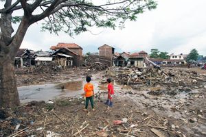
Fast forward to today, and it’s impossible to ignore that their predictions were all too accurate. Hurricanes Helene and Milton are stark examples. Both storms swelled to terrifying proportions, with Milton, in particular, becoming one of the most powerful hurricanes in recorded history.
Steve McLaughlin, an out meteorologist for NBC 6 in Miami, a city that's all too familiar with nature’s fury, said this is what could be expected going forward.
Was this something he foresaw as a student of meteorology? "Yes, we talked about it. But maybe I’m a little shocked at how fast it’s happening,” he said in a phone interview. “The rapid acceleration of these hurricanes has been the most jarring development. It’s not just that hurricanes are getting stronger; it’s that they’re growing in intensity with alarming speed.”
He cited Hurricane Otis, which was supposed to be a tropical storm but quickly turned into a Category 5 hurricane, as a glaring example. "We saw it with Idalia, Ida, Ian, and now Helene and Milton. These storms are exploding," McLaughlin emphasized.
Milton’s meteoric rise from a developing system to a Category 4 and then to a Category 5 monster in just days is a reflection of the unnaturally warm waters in the Gulf and the Atlantic.
"The Gulf of Mexico is hotter than it's ever been in the history of human existence," McLaughlin explained. “The catastrophic potential of these conditions is driven by this warm water, and it is the primary fuel for hurricanes, and as the oceans continue to heat up, the scale of storms we’re seeing could become the new normal.”
McLaughlin’s colleague at NBC 6, John Morales, a veteran hurricane expert and meteorologist at the station, was brought to tears on air about the savage impending storm. "It's just an incredible, incredible, incredible hurricane. It has dropped…It has dropped 50 millibars in 10 hours. I apologize. This is just horrific,” he said.
With the ferociousness of these storms on the rise, there have been ongoing discussions around balancing between adaptation and mitigation. “Adaptations quickly become irrelevant. Sea levels are rising so fast that the measures we take today may need to be redone in 10 years,” McLaughlin warned. "Adaptation buys us time, but if we’re not also mitigating—cutting back on fossil fuels and attacking the root of climate change—it’s just a band-aid.”
And McLaughlin validated what I remember climate scientists telling me, someday Florida, and other coastal areas, as we know them, won’t be here. “If we don’t tackle both adaptation and mitigation, in 20 years, Florida is going to look entirely different. This is why mitigation remains the central focus in the fight against climate change. Without efforts to cut carbon emissions, even the most well-engineered adaptations will be swallowed by rising seas.”
As we discussed the future of Florida, McLaughlin didn't mince words. "There are parts of South Florida that people won’t be able to live in 20 years," he cautioned. “The Florida Keys are already seeing this reality, with the government buying out land to prevent further development in vulnerable areas. The sea is rising faster than many anticipated, and even if we stopped all greenhouse gas emissions today, the damage already done will continue to unfold.”
McLaughlin painted a grim picture of the Florida coastline: "Our job right now is to do everything we can to make sure the next generation has a fighting chance to end climate change. But while we can't stop what’s already in motion, there is hope for slowing it down. The Paris Agreement and other international efforts show a path forward, though they need more global participation and political will to be effective.”
One of the most chilling moments in our conversation was McLaughlin's reflection on how the unpredictability of these storms adds another layer of danger. "It's almost like playing roulette," he said, referencing how many of the recent storms from the Atlantic have curved away from the coast—narrowly avoiding disaster for major cities. In fact, what makes Milton more potent is the fact that Tampa, where it’s expected to make landfall, hasn’t had a direct hit since 1921.
“This luck won’t hold out forever,” McLaughlin predicted. “If one of these storms hits a warm patch in the Atlantic and doesn’t turn away, we’re looking at devastation for the East Coast that we haven’t seen before.”